Trail Walking Molompize - La Vallée de la Sianne - Molompize - Photo

La Vallée de la Sianne - Molompize

 tracegps
tracegps

User

© OpenStreetMap contributors
Length
Length
15.2 km
Max alt
Max alt
893 m
Uphill gradient
Uphill gradient
628 m
Km-Effort
Km-Effort  
24 km
Min alt
Min alt
554 m
Downhill gradient
Downhill gradient
631 m
Boucle
Boucle
Yes
Creation date :
2014-12-10 00:00:00.0
Updated on :
2014-12-10 00:00:00.0

(0 Reviews)

Walking
Walking
5h00
Difficulty : Difficult

Scan this QR Code to open this trail in the SityTrail application

FREE GPS app for hiking

Logo SityTrail SityTrail

IGN / Geographical institutes

Download SityTrail from the App Store Download SityTrail from Google Play

Logo SityTrail SityTrail World

The world is yours!

Download SityTrail from the App Store Download SityTrail from Google Play Download SityTrail on Huawei AppGallery

About

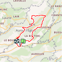
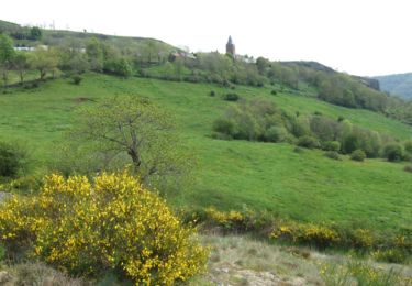
Trail Walking of 15.2 km to be discovered at Auvergne-Rhône-Alpes, Cantal, Molompize. This trail is proposed by tracegps.

Description

Départ près de la Baraque de la Pinatelle, sur la D21. Un itinéraire pour bons marcheurs avec deux pentes pas très longues mais totalisant 500m. de dénivelé. Belles vues sur les hauteurs.

Elevation profile

Photos

Points of interest

Point of interest Auriac-l'Église - cascade - Photo
tracegps
AURIAC-L'ÉGLISE 
Point of interest Molompize - départ - Photo
tracegps
MOLOMPIZE 
Point of interest Auriac-l'Église - pique nique - Photo
tracegps
AURIAC-L'ÉGLISE 

Positioning

Country:
France
Region :
Auvergne-Rhône-Alpes
Department/Province :
Cantal
Municipality :
Molompize
Location:
Unknown
Start:(UTM)
509389 ; 5010456 (31T) N.

Trails nearby

Trail Walking Molompize - Cantal - Molompize - Aurouze et Suc de Védrines - 17.7km 770m 7h05 - 2019 07 02 - Photo
Walking
Orcal37

Walking

Medium
Molompize, Auvergne-Rhône-Alpes, Cantal, France
17.7 km | 28 km-effort
7h 0min
Yes
Trail Walking Molompize - Hike 318 jour 1 - Photo
Walking
albert318

Walking

Medium
Molompize, Auvergne-Rhône-Alpes, Cantal, France
14.2 km | 21 km-effort
6h 45min
No
Trail Walking Molompize - La chapelle de Vauclair - Photo
Walking
tracegps

Walking

Difficult
Molompize, Auvergne-Rhône-Alpes, Cantal, France
11.2 km | 17.7 km-effort
3h 15min
Yes
Trail Walking Laurie - Laurie Védrines Laurie - Photo
Walking
seb0043

Walking

Very easy
Laurie, Auvergne-Rhône-Alpes, Cantal, France
13.5 km | 17.8 km-effort
3h 48min
No
Trail Walking Molompize - Des Pierres et des hommes - Molompize - Photo
Walking
tracegps

Walking

Medium
Molompize, Auvergne-Rhône-Alpes, Cantal, France
13.6 km | 22 km-effort
5h 40min
Yes
Trail Walking Bonnac - Bonnac 2 - Photo
Walking
jlgauthi25

Walking

Easy
Bonnac, Auvergne-Rhône-Alpes, Cantal, France
30 km | 40 km-effort
3h 9min
Yes
Trail Equestrian Laurie - Cez5.3 Chalinargues - Laurie (29) - Photo
Equestrian
hdetarle

Equestrian

Medium
Laurie, Auvergne-Rhône-Alpes, Cantal, France
28 km | 41 km-effort
8h 8min
No
Trail Equestrian Laurie - Cez5.4 Laurie Bouttares (30) - Photo
Equestrian
hdetarle

Equestrian

Medium
Laurie, Auvergne-Rhône-Alpes, Cantal, France
30 km | 43 km-effort
7h 58min
No


Close
My subscriptions