Trail Walking Ambly-Fleury - Château de Thugny Trugny - Ambly Fleury - Photo

Château de Thugny Trugny - Ambly Fleury

 tracegps
tracegps

User

© OpenStreetMap contributors
Length
Length
14.1 km
Max alt
Max alt
139 m
Uphill gradient
Uphill gradient
144 m
Km-Effort
Km-Effort  
16 km
Min alt
Min alt
70 m
Downhill gradient
Downhill gradient
144 m
Boucle
Boucle
Yes
Creation date :
2014-12-10 00:00:00.0
Updated on :
2014-12-10 00:00:00.0

(0 Reviews)

Walking
Walking
3h49
Difficulty : Difficult

Scan this QR Code to open this trail in the SityTrail application

FREE GPS app for hiking

Logo SityTrail SityTrail

IGN / Geographical institutes

Download SityTrail from the App Store Download SityTrail from Google Play

Logo SityTrail SityTrail World

The world is yours!

Download SityTrail from the App Store Download SityTrail from Google Play Download SityTrail on Huawei AppGallery

About

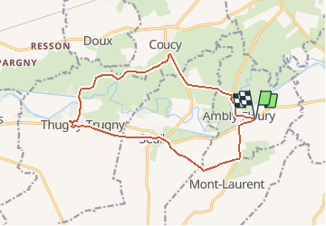
Trail Walking of 14.1 km to be discovered at Grand Est, Ardennes, Ambly-Fleury. This trail is proposed by tracegps.

Description

Départ château d'eau d'Ambly-Fleury. On suit un chemin au milieu des prairies longeant l'Aisne jusqu'au magnifique château de Thugny-Trugny. Ensuite vous passez devant le monument où gisent des soldats français tués lors de la bataille du pont de Thugny en 1650 commandé par Turenne ??? Voir aussi l'église de Seuil et d'Ambly Fleury.

Elevation profile

Photos

Positioning

Country:
France
Region :
Grand Est
Department/Province :
Ardennes
Municipality :
Ambly-Fleury
Location:
Unknown
Start:(UTM)
608013 ; 5482515 (31U) N.

Trails nearby

Trail Mountain bike Givry - Givry Le Chesne Voie Verte - Photo
Mountain bike
ThierryLECLERC

Mountain bike

Easy
Givry, Grand Est, Ardennes, France
41 km | 45 km-effort
2h 28min
Yes
Trail sport Amagne -  - Photo
sport
paffou

sport

Very easy
Amagne, Grand Est, Ardennes, France
53 km | 72 km-effort
Unknown
No


Close
My subscriptions