


Lacs de Lignin

jmheydorff
User


6h00
Difficulty : Medium

FREE GPS app for hiking
 SityTrail
IGN / Geographical institutes
SityTrail Plus
The world is yours!
About
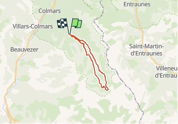
Trail Walking of 17.6 km to be discovered at Provence-Alpes-Côte d'Azur, Alpes-de-Haute-Provence, Colmars. This trail is proposed by jmheydorff.
Description
Depuis Colmars,Sud sur RD 908; à 800m, prendre piste goudronnée vers La Buissière,puis continuer en montant une piste forestière, jusqu'au Pkg (alt.1633m) au bord de la lance, 4 kms après la D 908.
Voir d'abord la cascade en dessous du Pkg, puis monter le ruisseau de la Lance en rive droite, en passant par le hameau du Pont de La serre (2° pkg possible).
jusqu'aux lacs de Lignin (alt.2273 m).
revenir par la rive gauche de la Lance, en suivant le ruisseau, ou en passant par le haut des falaises (H 200m), sous le sommet de La Mole et du petit Coyer.
Positioning
Comments