


Müllerthal Extra Trail C

flip96
User

Length
9.9 km

Max alt
400 m

Uphill gradient
248 m
Km-Effort
13.2 km

Min alt
304 m

Downhill gradient
247 m
Boucle
Yes
Creation date :
2014-12-10 00:00:00.0
Updated on :
2014-12-10 00:00:00.0
2h50
Difficulty : Easy

FREE GPS app for hiking
 SityTrail
IGN / Geographical institutes
SityTrail Plus
The world is yours!
About
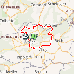
Trail Walking of 9.9 km to be discovered at Unknown, Canton Echternach, Bech. This trail is proposed by flip96.
Description
Müllerthal Extra Trail C 10km.
Gestart in Altrier waar parkeerplaats is aan kruising Op der Schanz met Heeschbregerwee.
Mooie, eenvoudige wandeling.
Opmerkingen? flip96@home.nl
Positioning
Country:
Luxembourg
Region :
Unknown
Department/Province :
Canton Echternach
Municipality :
Bech
Location:
Unknown
Start:(Dec)
Start:(UTM)
307547 ; 5514291 (32U) N.
Comments