


Puy Griou

frizou83
User
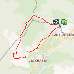

Length
7.2 km

Max alt
1578 m

Uphill gradient
379 m
Km-Effort
12.2 km

Min alt
1209 m

Downhill gradient
368 m
Boucle
Yes
Creation date :
2014-12-10 00:00:00.0
Updated on :
2014-12-10 00:00:00.0
2h43
Difficulty : Medium

FREE GPS app for hiking
 SityTrail
IGN / Geographical institutes
SityTrail Plus
The world is yours!
About
Trail Walking of 7.2 km to be discovered at Auvergne-Rhône-Alpes, Cantal, Saint-Jacques-des-Blats. This trail is proposed by frizou83.
Positioning
Country:
France
Region :
Auvergne-Rhône-Alpes
Department/Province :
Cantal
Municipality :
Saint-Jacques-des-Blats
Location:
Unknown
Start:(Dec)
Start:(UTM)
478969 ; 4992459 (31T) N.
Comments