


luminy-morgiou-cap morgiou-aiguille sormiou-col morgiou-estampons

mapomme
User


6h24
Difficulty : Unknown

FREE GPS app for hiking
 SityTrail
IGN / Geographical institutes
SityTrail Plus
The world is yours!
About
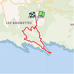
Trail Walking of 14.8 km to be discovered at Provence-Alpes-Côte d'Azur, Bouches-du-Rhône, Marseille. This trail is proposed by mapomme.
Description
Une très tres belle ballade-assez longue-très beaux points de vue-bcp hors sentiers balisés. Boucle perso qui surprendra même les habitues. Permet d échapper à la foule et de voir des panoramas exceptionnels
Photos


Positioning
Comments
très bien. merci