


FestaTrail_2013

wviel
User

Length
17.1 km

Max alt
538 m

Uphill gradient
766 m
Km-Effort
27 km

Min alt
97 m

Downhill gradient
765 m
Boucle
Yes
Creation date :
2014-12-10 00:00:00.0
Updated on :
2014-12-10 00:00:00.0
2h13
Difficulty : Difficult

FREE GPS app for hiking
 SityTrail
IGN / Geographical institutes
SityTrail Plus
The world is yours!
About
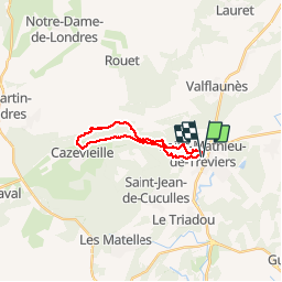
Trail Running of 17.1 km to be discovered at Occitania, Hérault, Saint-Mathieu-de-Tréviers. This trail is proposed by wviel.
Positioning
Country:
France
Region :
Occitania
Department/Province :
Hérault
Municipality :
Saint-Mathieu-de-Tréviers
Location:
Unknown
Start:(Dec)
Start:(UTM)
569566 ; 4846476 (31T) N.
Comments