


étape3 Merdrignac-Ploermel

mikaelerouzic
User
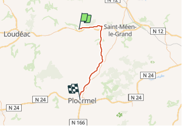

Length
45 km

Max alt
159 m

Uphill gradient
344 m
Km-Effort
50 km

Min alt
33 m

Downhill gradient
432 m
Boucle
No
Creation date :
2014-12-10 00:00:00.0
Updated on :
2014-12-10 00:00:00.0
6h00
Difficulty : Very easy

FREE GPS app for hiking
 SityTrail
IGN / Geographical institutes
SityTrail Plus
The world is yours!
About
Trail Running of 45 km to be discovered at Brittany, Côtes-d'Armor, Merdrignac. This trail is proposed by mikaelerouzic.
Positioning
Country:
France
Region :
Brittany
Department/Province :
Côtes-d'Armor
Municipality :
Merdrignac
Location:
Unknown
Start:(Dec)
Start:(UTM)
543488 ; 5337766 (30U) N.
Comments