


Forêt de Stella

jmheydorff
User

Length
12.4 km

Max alt
1219 m

Uphill gradient
627 m
Km-Effort
21 km

Min alt
673 m

Downhill gradient
616 m
Boucle
Yes
Creation date :
2014-12-10 00:00:00.0
Updated on :
2014-12-10 00:00:00.0
4h14
Difficulty : Medium

FREE GPS app for hiking
 SityTrail
IGN / Geographical institutes
SityTrail Plus
The world is yours!
About
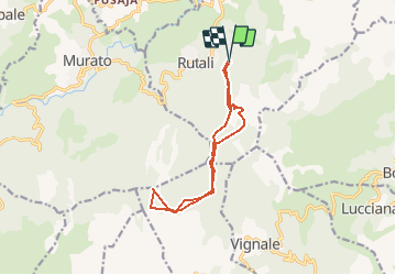
Trail Walking of 12.4 km to be discovered at Corsica, Haute-Corse, Rutali. This trail is proposed by jmheydorff.
Description
départ Rutali,. Prendre Est la route de la chapelle Ste Chiara (belle vue sur la côte Est). revenir au croisement (alt. 760m), prendre Sud la piste direction "Forêt de Stella".
Positioning
Country:
France
Region :
Corsica
Department/Province :
Haute-Corse
Municipality :
Rutali
Location:
Unknown
Start:(Dec)
Start:(UTM)
530634 ; 4714224 (32T) N.
Comments