Nonza Cime de Muzzicone

jmheydorff
User


5h07
Difficulty : Medium

FREE GPS app for hiking
 SityTrail
IGN / Geographical institutes
SityTrail Plus
The world is yours!
About
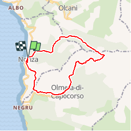
Trail Walking of 13.7 km to be discovered at Corsica, Haute-Corse, Nonza. This trail is proposed by jmheydorff.
Description
départ CV Nonza (alt. 130m).
Prendre est la route; à 250m, monter dans sentier fléché "Olcani par Bocca di Violu".
Peu après la chapelle Sta Maria, monter fortement à droite, et contourner Cimone par le Nord.
250 m après le col de Puratellu, prendre le raccourcis qui descend à la bergerie de Laggiarelli, où l''on reprend le sentier qui nous amène au village dOlmeta di Capocorso (hameau de Poggio), que l''on traverse par le haut, pour chercher le sentier qui nous ramène à Nonza, en surplombant la RD 433 jusqu''au col de Negru, puis nous procure de magnifiques vues sur le village et la plage de Nonza
Positioning
Comments