


GTJ LA Rasse Goumois

svp59
User
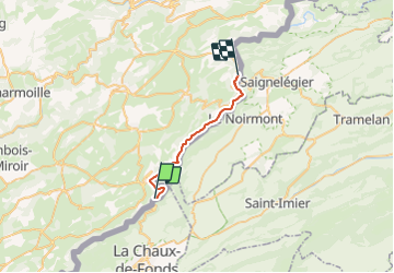

Length
19.2 km

Max alt
686 m

Uphill gradient
453 m
Km-Effort
26 km

Min alt
501 m

Downhill gradient
578 m
Boucle
No
Creation date :
2014-12-10 00:00:00.0
Updated on :
2014-12-10 00:00:00.0
8h00
Difficulty : Medium

FREE GPS app for hiking
 SityTrail
IGN / Geographical institutes
SityTrail Plus
The world is yours!
About
Trail Walking of 19.2 km to be discovered at Bourgogne-Franche-Comté, Doubs, Fournet-Blancheroche. This trail is proposed by svp59.
Description
La Rasse- Goumois
Positioning
Country:
France
Region :
Bourgogne-Franche-Comté
Department/Province :
Doubs
Municipality :
Fournet-Blancheroche
Location:
Unknown
Start:(Dec)
Start:(UTM)
336601 ; 5224691 (32T) N.
Comments