


ruisseau de Pietracorbara

jmheydorff
User


5h51
Difficulty : Easy

FREE GPS app for hiking
 SityTrail
IGN / Geographical institutes
SityTrail Plus
The world is yours!
About
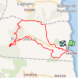
Trail Walking of 18.8 km to be discovered at Corsica, Haute-Corse, Pietracorbara. This trail is proposed by jmheydorff.
Description
Départ Pont du ruisseau de la Marine de Pietracorba.
Remonter en rive droite le ruisseau; puis se balader dans la campagne, pour revenir longer le ruisseau de Pietracorba, et le traverser sur un premier pont génois à Oreta. A la sortie ouest d'Oreta, on quitte Sud la route pour retraverser 2 fois le ruisseau.
on quiite le ruisseau, pour monter rejoindre la route RD 32, que l'on suit jusqu'à Lapedina (alt. 400 m); de là, on rejoint NE la piste hiorizontale de crête vers l'Est (belles vues); on descend alors rapidement vers la vallée, rejoindre la RD 232; faire un petit AR vers un autre pont génois, puis revenirà la marine de Pietracorbara.
Positioning
Comments