


2013-06-02 Balade VerloreneEck par le Fackenthal

holtzv
User GUIDE
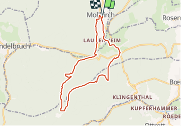

Length
15 km

Max alt
612 m

Uphill gradient
421 m
Km-Effort
21 km

Min alt
288 m

Downhill gradient
421 m
Boucle
Yes
Creation date :
2014-12-10 00:00:00.0
Updated on :
2014-12-10 00:00:00.0
2h33
Difficulty : Easy

FREE GPS app for hiking
 SityTrail
IGN / Geographical institutes
SityTrail Plus
The world is yours!
About
Trail Equestrian of 15 km to be discovered at Grand Est, Bas-Rhin, Mollkirch. This trail is proposed by holtzv.
Positioning
Country:
France
Region :
Grand Est
Department/Province :
Bas-Rhin
Municipality :
Mollkirch
Location:
Unknown
Start:(Dec)
Start:(UTM)
380899 ; 5373910 (32U) N.
Comments