


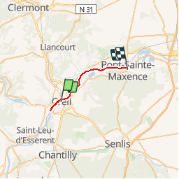
Creil_Pont AU5V

gilbertdu60
User

Length
17.1 km

Max alt
37 m

Uphill gradient
121 m
Km-Effort
18.7 km

Min alt
20 m

Downhill gradient
115 m
Boucle
No
Creation date :
2014-12-10 00:00:00.0
Updated on :
2014-12-10 00:00:00.0
1h15
Difficulty : Medium

FREE GPS app for hiking
 SityTrail
IGN / Geographical institutes
SityTrail Plus
The world is yours!
About
Trail Mountain bike of 17.1 km to be discovered at Hauts-de-France, Oise, Creil. This trail is proposed by gilbertdu60.
Description
Creil Pont ste Maxence en vélo par les anciens chemins de halage sortie AU5V
Positioning
Country:
France
Region :
Hauts-de-France
Department/Province :
Oise
Municipality :
Creil
Location:
Unknown
Start:(Dec)
Start:(UTM)
461680 ; 5456562 (31U) N.
Comments