


Monte ASTU direct

jmheydorff
User

Length
6.1 km

Max alt
1511 m

Uphill gradient
1004 m
Km-Effort
16.3 km

Min alt
528 m

Downhill gradient
31 m
Boucle
No
Creation date :
2014-12-10 00:00:00.0
Updated on :
2014-12-10 00:00:00.0
3h41
Difficulty : Medium

FREE GPS app for hiking
 SityTrail
IGN / Geographical institutes
SityTrail Plus
The world is yours!
About
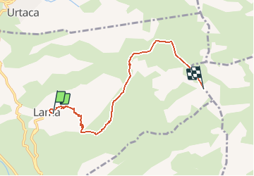
Trail Walking of 6.1 km to be discovered at Corsica, Haute-Corse, Lama. This trail is proposed by jmheydorff.
Description
Lama; partir du haut du village, et monter les escaliers ; le sentier nous fait monter au Mont Asto.
revenir par le même sentier.
En AR, distance: 12,5 kms dénivelé: 1060m durée: 5h30
Positioning
Country:
France
Region :
Corsica
Department/Province :
Haute-Corse
Municipality :
Lama
Location:
Unknown
Start:(Dec)
Start:(UTM)
514223 ; 4713800 (32T) N.
Comments