Trail Walking Centuri - Centuri, autour du monte Maggiore - Photo

Centuri, autour du monte Maggiore

© OpenStreetMap contributors
Length
Length
17.1 km
Max alt
Max alt
395 m
Uphill gradient
Uphill gradient
760 m
Km-Effort
Km-Effort  
27 km
Min alt
Min alt
0 m
Downhill gradient
Downhill gradient
759 m
Boucle
Boucle
Yes
Creation date :
2014-12-10 00:00:00.0
Updated on :
2014-12-10 00:00:00.0

(1 Reviews)

Walking
Walking
5h41
Difficulty : Medium

Scan this QR Code to open this trail in the SityTrail application

FREE GPS app for hiking

Logo SityTrail SityTrail

IGN / Geographical institutes

Download SityTrail from the App Store Download SityTrail from Google Play

Logo SityTrail SityTrail World

The world is yours!

Download SityTrail from the App Store Download SityTrail from Google Play Download SityTrail on Huawei AppGallery

About

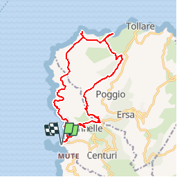
Trail Walking of 17.1 km to be discovered at Corsica, Haute-Corse, Centuri. This trail is proposed by jmheydorff.

Description

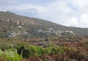
Départ centuri. monter à Canelle (visiter le village).
Rejoindre le col de serra, et le belvédère du moulin Mattei (alt.404m).
continuer N en ligne de crête; on se trouve en NE sur la crête du Monte longo; la descendre jusqu'au bas du Monte maggiore.
Prendre W puis N la piste qui nous mène ao monte Riuzulu et à sa plagette Est.
rejoindre la piste du bord de mer, que l'on prendra W pour revenir à Centuri

Elevation profile

Positioning

Country:
France
Region :
Corsica
Department/Province :
Haute-Corse
Municipality :
Centuri
Location:
Unknown
Start:(UTM)
528389 ; 4756939 (32T) N.

Comments

Please log in to post a review or rate the element


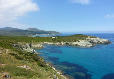
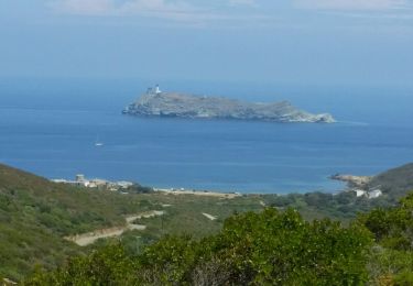
Prendre au moins 2l d'eau par personne. Assez physique avec la dénivellation. Superbe randonnée dans un lieu sauvage et où l'on croise très peu de gens. (Un couple et un apiculteur sur toute la randonnée)


Trails nearby

Trail Walking Ersa - Cap Corse 6 - Photo
Walking
copter

Walking

Easy
(1)
Ersa, Corsica, Haute-Corse, France
12.1 km | 15.9 km-effort
3h 24min
No
Trail Walking Ersa - 05/06/2013 10:16 Barcaggio Tour D Agnello - Photo
Walking
Orcal37

Walking

Medium
Ersa, Corsica, Haute-Corse, France
7.7 km | 10.1 km-effort
2h 10min
Yes
Trail Other activity Morsiglia - cap notre Dame des grâce (Meria)-Tamarone (chm des doiniers) - Photo
Other activity
Natalini

Other activity

Very easy
(1)
Morsiglia, Corsica, Haute-Corse, France
28 km | 40 km-effort
8h 52min
No
Trail Walking Centuri - Port de Centuri - Cannelle - Moulin Cap Corse - Chemin douanier - Photo
Walking
jean.marie.litzler@gmail.com

Walking

Medium
Centuri, Corsica, Haute-Corse, France
16.8 km | 26 km-effort
5h 46min
Yes
Trail On foot Centuri - Centuri Cannelle - Photo
On foot
Laurent53

On foot

Easy
Centuri, Corsica, Haute-Corse, France
4.3 km | 6.1 km-effort
1h 23min
Yes
Trail Walking Morsiglia - baragogna - Photo
Walking
nicolasdresse

Walking

Easy
Morsiglia, Corsica, Haute-Corse, France
10.1 km | 18.6 km-effort
1h 24min
No
Trail Walking Centuri - 6km centuri - Photo
Walking
famillerudent

Walking

Very easy
Centuri, Corsica, Haute-Corse, France
6.1 km | 8.4 km-effort
3h 11min
Yes
Trail Cycle Morsiglia - Randonnée des cols Corse étape 2 - Photo
Cycle
lagardienne

Cycle

Medium
Morsiglia, Corsica, Haute-Corse, France
68 km | 89 km-effort
7h 8min
No
Trail Walking Centuri - grotte del piane - Photo
Walking
romain-donner

Walking

Medium
Centuri, Corsica, Haute-Corse, France
9.9 km | 14.7 km-effort
4h 45min
Yes


Close
My subscriptions