


08/06/2013

hm
User
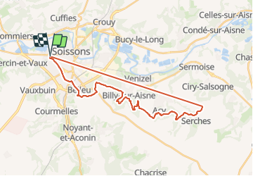

Length
31 km

Max alt
162 m

Uphill gradient
478 m
Km-Effort
37 km

Min alt
40 m

Downhill gradient
478 m
Boucle
Yes
Creation date :
2014-12-10 00:00:00.0
Updated on :
2014-12-10 00:00:00.0
2h27
Difficulty : Very easy

FREE GPS app for hiking
 SityTrail
IGN / Geographical institutes
SityTrail Plus
The world is yours!
About
Trail Mountain bike of 31 km to be discovered at Hauts-de-France, Aisne, Soissons. This trail is proposed by hm.
Description
hm
Positioning
Country:
France
Region :
Hauts-de-France
Department/Province :
Aisne
Municipality :
Soissons
Location:
Unknown
Start:(Dec)
Start:(UTM)
522333 ; 5469761 (31U) N.
Comments