


Luthernbad - Trachselegg - Napf

bayardpaul
User
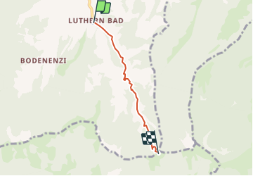

Length
3.3 km

Max alt
1387 m

Uphill gradient
506 m
Km-Effort
8.4 km

Min alt
878 m

Downhill gradient
0 m
Boucle
No
Creation date :
2014-12-11 00:00:00.0
Updated on :
2014-12-11 00:00:00.0
--
Difficulty : Unknown

FREE GPS app for hiking
 SityTrail
IGN / Geographical institutes
SityTrail Plus
The world is yours!
About
Trail Other activity of 3.3 km to be discovered at Luzern, Unknown, Luthern. This trail is proposed by bayardpaul.
Description
Leubin-Huber Hansrudolf
Bahnhofstrasse 51
4132 Muttenz
061 461 43 28
Positioning
Country:
Switzerland
Region :
Luzern
Department/Province :
Unknown
Municipality :
Luthern
Location:
Unknown
Start:(Dec)
Start:(UTM)
418332 ; 5208739 (32T) N.
Comments