Trail Walking Quinson - Au dessus de Quinson - Photo
© OpenStreetMap contributors
Length
Length
4.7 km
Max alt
Max alt
546 m
Uphill gradient
Uphill gradient
183 m
Km-Effort
Km-Effort  
7.2 km
Min alt
Min alt
367 m
Downhill gradient
Downhill gradient
183 m
Boucle
Boucle
Yes
Creation date :
2014-12-10 00:00:00.0
Updated on :
2014-12-10 00:00:00.0

(0 Reviews)

Walking
Walking
1h32
Difficulty : Medium

Scan this QR Code to open this trail in the SityTrail application

FREE GPS app for hiking

Logo SityTrail SityTrail

IGN / Geographical institutes

Download SityTrail from the App Store Download SityTrail from Google Play

Logo SityTrail SityTrail Plus

The world is yours!

Download SityTrail from the App Store Download SityTrail from Google Play Download SityTrail on Huawei AppGallery

About

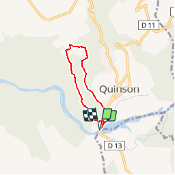
Trail Walking of 4.7 km to be discovered at Provence-Alpes-Côte d'Azur, Alpes-de-Haute-Provence, Quinson. This trail is proposed by jmheydorff.

Description

Pkg Pont de Quinson, ou musée de la Préhistoire.
Dans le virage entre les 2 pkgs, prendre la piste W, et de suite SW le sentier qui monte un peu (ou prendre le raccourcis qui monte 150m   après le pont); puis ce sentier monte très fort jusqu'à la crête (vues vers le Sud).
On prend N le sentier horizontal de crête, jusqu'en limite de forêt; on traverse E un champ, puis on entre à nouveau dans un bois, pour prendre  SE puis S, un sentier qui redescend au village de Quinson

Elevation profile

Positioning

Country:
France
Region :
Provence-Alpes-Côte d'Azur
Department/Province :
Alpes-de-Haute-Provence
Municipality :
Quinson
Location:
Unknown
Start:(UTM)
261046 ; 4842218 (32T) N.


Close
My subscriptions