Trail Other activity Artignosc-sur-Verdon - Artignosc-Canoé Verdon - Photo
 Sugg
Sugg

User

© OpenStreetMap contributors
Length
Length
7.4 km
Max alt
Max alt
474 m
Uphill gradient
Uphill gradient
128 m
Km-Effort
Km-Effort  
9 km
Min alt
Min alt
399 m
Downhill gradient
Downhill gradient
93 m
Boucle
Boucle
No
Creation date :
2019-03-22 17:00:23.666
Updated on :
2019-03-22 17:00:23.702

(0 Reviews)

Other activity
Other activity
3h00
Difficulty : Medium

Scan this QR Code to open this trail in the SityTrail application

FREE GPS app for hiking

Logo SityTrail SityTrail

IGN / Geographical institutes

Download SityTrail from the App Store Download SityTrail from Google Play

Logo SityTrail SityTrail Plus

The world is yours!

Download SityTrail from the App Store Download SityTrail from Google Play Download SityTrail on Huawei AppGallery

About

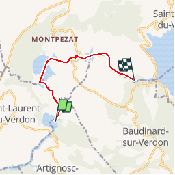
Trail Other activity of 7.4 km to be discovered at Provence-Alpes-Côte d'Azur, Var, Artignosc-sur-Verdon. This trail is proposed by Sugg.

Description

Ballade à deux en canoë gonflable ( Colorado )
Ce tracé est l''aller ( plage d'Artignosc au  dernier point avant le barrage ), contre le léger courant, le retour ( non tracé ) est aussi contre le courant, car il y a inversion dans l''après midi....dur dur...et un vent contraire s''est installé sur la fin du retour dans les dernières gorges.Trop long pour une première fois( surtout avec ce type de canoë )
Total 5 heures de pagaie Berkkkkkk.

Elevation profile

Positioning

Country:
France
Region :
Provence-Alpes-Côte d'Azur
Department/Province :
Var
Municipality :
Artignosc-sur-Verdon
Location:
Unknown
Start:(UTM)
265563 ; 4845109 (32T) N.


Close
My subscriptions