


retour

pconte
User
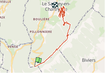

Length
9.7 km

Max alt
1342 m

Uphill gradient
438 m
Km-Effort
16.6 km

Min alt
983 m

Downhill gradient
741 m
Boucle
No
Creation date :
2014-12-10 00:00:00.0
Updated on :
2014-12-10 00:00:00.0
2h07
Difficulty : Unknown

FREE GPS app for hiking
 SityTrail
IGN / Geographical institutes
SityTrail Plus
The world is yours!
About
Trail Walking of 9.7 km to be discovered at Auvergne-Rhône-Alpes, Isère, Le Sappey-en-Chartreuse. This trail is proposed by pconte.
Positioning
Country:
France
Region :
Auvergne-Rhône-Alpes
Department/Province :
Isère
Municipality :
Le Sappey-en-Chartreuse
Location:
Unknown
Start:(Dec)
Start:(UTM)
716999 ; 5012767 (31T) N.
Comments