


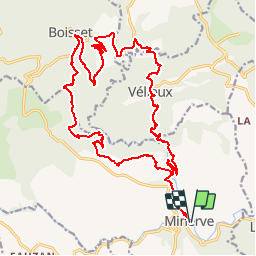
Minerve

Chapatann
User

Length
27 km

Max alt
541 m

Uphill gradient
1135 m
Km-Effort
42 km

Min alt
180 m

Downhill gradient
1136 m
Boucle
Yes
Creation date :
2014-12-10 00:00:00.0
Updated on :
2014-12-10 00:00:00.0
7h00
Difficulty : Difficult

FREE GPS app for hiking
 SityTrail
IGN / Geographical institutes
SityTrail Plus
The world is yours!
About
Trail Walking of 27 km to be discovered at Occitania, Hérault, Minerve. This trail is proposed by Chapatann.
Description
Entre village médiéval et les bois...
Positioning
Country:
France
Region :
Occitania
Department/Province :
Hérault
Municipality :
Minerve
Location:
Unknown
Start:(Dec)
Start:(UTM)
479489 ; 4800127 (31T) N.
Comments
