


7878274-ZLes Aspres 41

togolo28
User
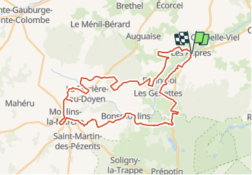

Length
40 km

Max alt
289 m

Uphill gradient
490 m
Km-Effort
47 km

Min alt
207 m

Downhill gradient
487 m
Boucle
Yes
Creation date :
2018-05-06 16:00:29.059
Updated on :
2018-05-06 16:01:00.772
--
Difficulty : Difficult

FREE GPS app for hiking
 SityTrail
IGN / Geographical institutes
SityTrail Plus
The world is yours!
About
Trail Walking of 40 km to be discovered at Normandy, Orne, Les Aspres. This trail is proposed by togolo28.
Positioning
Country:
France
Region :
Normandy
Department/Province :
Orne
Municipality :
Les Aspres
Location:
Unknown
Start:(Dec)
Start:(UTM)
323444 ; 5395693 (31U) N.
Comments