


8643488-Yèvres 21.61

togolo28
User
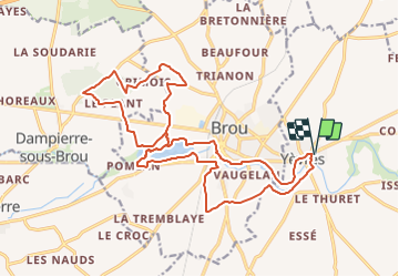

Length
22 km

Max alt
211 m

Uphill gradient
176 m
Km-Effort
24 km

Min alt
145 m

Downhill gradient
176 m
Boucle
Yes
Creation date :
2018-05-10 12:45:35.105
Updated on :
2018-05-10 12:46:19.465
--
Difficulty : Medium

FREE GPS app for hiking
 SityTrail
IGN / Geographical institutes
SityTrail Plus
The world is yours!
About
Trail Walking of 22 km to be discovered at Centre-Loire Valley, Eure-et-Loir, Yèvres. This trail is proposed by togolo28.
Description
Randonnée Yèvres Ascension 2018
Positioning
Country:
France
Region :
Centre-Loire Valley
Department/Province :
Eure-et-Loir
Municipality :
Yèvres
Location:
Unknown
Start:(Dec)
Start:(UTM)
365736 ; 5341240 (31U) N.
Comments