


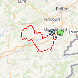
Du coté de L'Isle sur le Doubs

tiene
User

Length
89 km

Max alt
494 m

Uphill gradient
1407 m
Km-Effort
108 km

Min alt
286 m

Downhill gradient
1407 m
Boucle
Yes
Creation date :
2018-05-10 13:46:59.724
Updated on :
2018-06-20 06:08:41.721
6h16
Difficulty : Difficult

FREE GPS app for hiking
 SityTrail
IGN / Geographical institutes
SityTrail Plus
The world is yours!
About
Trail Road bike of 89 km to be discovered at Bourgogne-Franche-Comté, Doubs, Mandeure. This trail is proposed by tiene.
Description
Départ de Mandeure
Positioning
Country:
France
Region :
Bourgogne-Franche-Comté
Department/Province :
Doubs
Municipality :
Mandeure
Location:
Unknown
Start:(Dec)
Start:(UTM)
334614 ; 5257600 (32T) N.
Comments