


8653704-Erang de la Courrairerie 22.79

togolo28
User
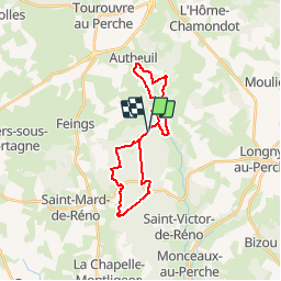

Length
23 km

Max alt
266 m

Uphill gradient
385 m
Km-Effort
28 km

Min alt
171 m

Downhill gradient
384 m
Boucle
Yes
Creation date :
2018-05-12 20:32:06.58
Updated on :
2019-09-07 11:29:37.879
--
Difficulty : Medium

FREE GPS app for hiking
 SityTrail
IGN / Geographical institutes
SityTrail Plus
The world is yours!
About
Trail Walking of 23 km to be discovered at Normandy, Orne, Feings. This trail is proposed by togolo28.
Positioning
Country:
France
Region :
Normandy
Department/Province :
Orne
Municipality :
Feings
Location:
Unknown
Start:(Dec)
Start:(UTM)
328738 ; 5379088 (31U) N.
Comments