


L'Aupillon (Glandage)

Philindy26
User


5h00
Difficulty : Difficult

FREE GPS app for hiking
 SityTrail
IGN / Geographical institutes
SityTrail Plus
The world is yours!
About
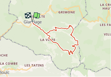
Trail Walking of 15.3 km to be discovered at Auvergne-Rhône-Alpes, Drôme, Glandage. This trail is proposed by Philindy26.
Description
Départ du village de Glandage au col de Grimone (860 m)...
Géolocalisation (Google Maps) : https://goo.gl/maps/j3NVeMoFk3DYwbGx5 .
Montée par le hameau "Les Maillefauds" (1026 m), le col des Aiguilles (1364 m), Serre les Têtes (1500 m), le col des Prêtres (1589 m) et l'Aupillon qui culmine à 1744 m.
Descente par le col de Lus (1497 m), puis la piste forestière par les Achards (1205 m), la Vière (1017 m), le hameau "Les Maillefauds" et retour à Glandage.
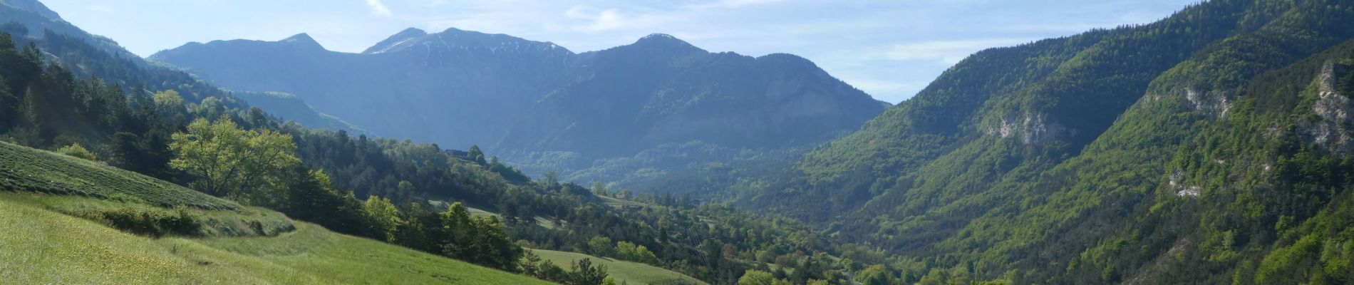
Au passage, vous pourrez admirer les faces nord très abruptes et minérales de la Toussière (1916 m) et de la Pale (1862 m).
Photos
 - Photo 1")
 - Photo 2")
 - Photo 3")
 - Photo 4")
 - Photo 5")
 - Photo 6")
 - Photo 7")
 - Photo 8")
 - Photo 9")
 - Photo 10")
 - Photo 11")
 - Photo 12")
 - Photo 13")
 - Photo 14")
 - Photo 15")
 - Photo 16")
 - Photo 17")
 - Photo 18")
 - Photo 19")
 - Photo 20")
 - Photo 21")
 - Photo 22")
 - Photo 23")
 - Photo 24")
 - Photo 25")
 - Photo 26")
 - Photo 27")
 - Photo 28")
 - Photo 29")
 - Photo 30")
 - Photo 31")
 - Photo 32")
 - Photo 33")
 - Photo 34")
 - Photo 35")
 - Photo 36")
 - Photo 37")
 - Photo 38")
 - Photo 39")
 - Photo 40")
 - Photo 41")
 - Photo 42")
 - Photo 43")
 - Photo 44")
 - Photo 45")
 - Photo 46")
 - Photo 47")
 - Photo 48")
 - Photo 49")
 - Photo 50")
 - Photo 51")
 - Photo 52")
 - Photo 53")
 - Photo 54")
 - Photo 55")
 - Photo 56")
 - Photo 57")
 - Photo 58")
 - Photo 59")
 - Photo 60")
 - Photo 61")
 - Photo 62")
 - Photo 63")
 - Photo 64")
 - Photo 65")
 - Photo 66")
 - Photo 67")
 - Photo 68")
 - Photo 69")
 - Photo 70")
 - Photo 71")
 - Photo 72")
 - Photo 73")
 - Photo 74")
 - Photo 75")
 - Photo 76")
 - Photo 77")
 - Photo 78")
 - Photo 79")
 - Photo 80")
 - Photo 81")
 - Photo 82")
 - Photo 83")
 - Photo 84")
 - Photo 85")
 - Photo 86")
 - Photo 87")
 - Photo 88")
 - Photo 89")
 - Photo 90")
 - Photo 91")
 - Photo 92")
 - Photo 93")
 - Photo 94")
 - Photo 95")
 - Photo 96")
 - Photo 97")
 - Photo 98")
 - Photo 99")
 - Photo 100")
 - Photo 101")
 - Photo 102")
 - Photo 103")
 - Photo 104")
 - Photo 105")
 - Photo 106")
 - Photo 107")
 - Photo 108")
 - Photo 109")
 - Photo 110")
 - Photo 111")
 - Photo 112")
 - Photo 113")
 - Photo 114")
 - Photo 115")
 - Photo 116")
116 photos in total. Please click on a photo to see them all in the gallery.
Positioning
Comments