


Aydat_Enfer_Montenard_JG_01

jagarnier
User GUIDE
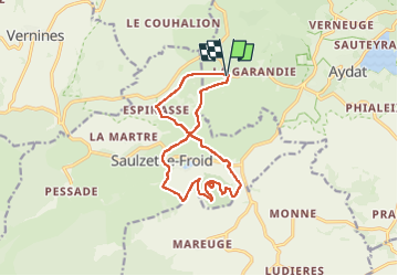

Length
13.7 km

Max alt
1170 m

Uphill gradient
355 m
Km-Effort
18.4 km

Min alt
986 m

Downhill gradient
355 m
Boucle
Yes
Creation date :
2018-05-21 08:10:49.248
Updated on :
2024-09-26 09:27:29.537
4h00
Difficulty : Medium

FREE GPS app for hiking
 SityTrail
IGN / Geographical institutes
SityTrail Plus
The world is yours!
About
Trail Walking of 13.7 km to be discovered at Auvergne-Rhône-Alpes, Puy-de-Dôme, Aydat. This trail is proposed by jagarnier.
Photos

Positioning
Country:
France
Region :
Auvergne-Rhône-Alpes
Department/Province :
Puy-de-Dôme
Municipality :
Aydat
Location:
Unknown
Start:(Dec)
Start:(UTM)
495197 ; 5056262 (31T) N.
Comments