


Nebouzat_Puy_Pourcharet_1_JG_02

jagarnier
User GUIDE

Length
18.8 km

Max alt
1065 m

Uphill gradient
356 m
Km-Effort
24 km

Min alt
840 m

Downhill gradient
357 m
Boucle
Yes
Creation date :
2018-05-25 09:46:14.625
Updated on :
2024-01-02 12:06:25.513
5h30
Difficulty : Medium

FREE GPS app for hiking
 SityTrail
IGN / Geographical institutes
SityTrail Plus
The world is yours!
About
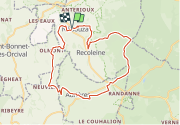
Trail Walking of 18.8 km to be discovered at Auvergne-Rhône-Alpes, Puy-de-Dôme, Nébouzat. This trail is proposed by jagarnier.
Photos

Positioning
Country:
France
Region :
Auvergne-Rhône-Alpes
Department/Province :
Puy-de-Dôme
Municipality :
Nébouzat
Location:
Unknown
Start:(Dec)
Start:(UTM)
492408 ; 5062480 (31T) N.
Comments