


2018-06-16 21:19:39

togolo28
User
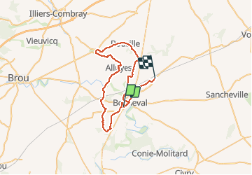

Length
49 km

Max alt
175 m

Uphill gradient
298 m
Km-Effort
53 km

Min alt
121 m

Downhill gradient
309 m
Boucle
No
Creation date :
2018-06-17 15:11:50.524
Updated on :
2018-06-17 15:12:27.094
11h50
Difficulty : Very difficult

FREE GPS app for hiking
 SityTrail
IGN / Geographical institutes
SityTrail Plus
The world is yours!
About
Trail Walking of 49 km to be discovered at Centre-Loire Valley, Eure-et-Loir, Bonneval. This trail is proposed by togolo28.
Positioning
Country:
France
Region :
Centre-Loire Valley
Department/Province :
Eure-et-Loir
Municipality :
Bonneval
Location:
Unknown
Start:(Dec)
Start:(UTM)
379115 ; 5337180 (31U) N.
Comments