F74120 Megève Christomet AR MJC

ageo
User
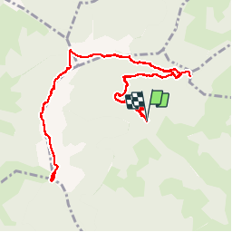

Length
14.1 km

Max alt
1842 m

Uphill gradient
587 m
Km-Effort
22 km

Min alt
1457 m

Downhill gradient
590 m
Boucle
Yes
Creation date :
2018-06-30 08:17:13.037
Updated on :
2018-07-07 07:24:07.044
4h32
Difficulty : Medium

FREE GPS app for hiking
 SityTrail
IGN / Geographical institutes
SityTrail Plus
The world is yours!
About
Trail Walking of 14.1 km to be discovered at Auvergne-Rhône-Alpes, Upper Savoy, Megève. This trail is proposed by ageo.
Description
File with points/tracks from Locus Map/3.31.3
Photos

Positioning
Country:
France
Region :
Auvergne-Rhône-Alpes
Department/Province :
Upper Savoy
Municipality :
Megève
Location:
Unknown
Start:(Dec)
Start:(UTM)
312642 ; 5082483 (32T) N.
Comments