


Les Gallinons- Le Môle

Kargil
User GUIDE
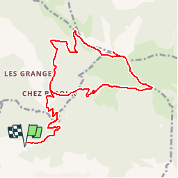

Length
12.2 km

Max alt
1842 m

Uphill gradient
1153 m
Km-Effort
28 km

Min alt
709 m

Downhill gradient
1153 m
Boucle
Yes
Creation date :
2018-07-08 08:34:20.056
Updated on :
2018-07-08 16:32:46.669
5h09
Difficulty : Difficult

FREE GPS app for hiking
 SityTrail
IGN / Geographical institutes
SityTrail Plus
The world is yours!
About
Trail Walking of 12.2 km to be discovered at Auvergne-Rhône-Alpes, Upper Savoy, Ayse. This trail is proposed by Kargil.
Description
Le Môle peut aussi cacher de beaux dénivelés
Positioning
Country:
France
Region :
Auvergne-Rhône-Alpes
Department/Province :
Upper Savoy
Municipality :
Ayse
Location:
Unknown
Start:(Dec)
Start:(UTM)
301546 ; 5107307 (32T) N.
Comments