


Le Pas du Touet - Le Pas Saint-Vincent

Philindy26
User


5h15
Difficulty : Difficult

FREE GPS app for hiking
 SityTrail
IGN / Geographical institutes
SityTrail Plus
The world is yours!
About
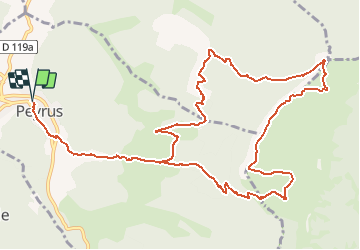
Trail Walking of 15.1 km to be discovered at Auvergne-Rhône-Alpes, Drôme, Peyrus. This trail is proposed by Philindy26.
Description
Départ de Peyrus, D68 direction le col des Limouches...
Géolocalisation (Google Maps) : https://goo.gl/maps/X2XxyHGvCgf8BCUi7 .
Montez au pas du Touet (1051 m) par le GR93 et suivre les crêtes en passant par le pylône de télécommunications.
Descente par le pas de Saint-Vincent (1112 m) et les Rochers de la Drayette.
Puis direction les Chabottes, les ruines des Blachons (667 m), les Vachères et Peyrus.
Photos


23 photos in total. Please click on a photo to see them all in the gallery.
Positioning
Comments