


Croix du Montaiguet

counoise
User

Length
13.9 km

Max alt
305 m

Uphill gradient
280 m
Km-Effort
17.6 km

Min alt
131 m

Downhill gradient
280 m
Boucle
Yes
Creation date :
2018-07-08 12:46:32.285
Updated on :
2018-07-08 16:12:26.701
3h21
Difficulty : Easy

FREE GPS app for hiking
 SityTrail
IGN / Geographical institutes
SityTrail Plus
The world is yours!
About
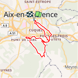
Trail Walking of 13.9 km to be discovered at Provence-Alpes-Côte d'Azur, Bouches-du-Rhône, Aix-en-Provence. This trail is proposed by counoise.
Description
La Croix du Montaiguet en boucle depuis le centre d'Aix
Positioning
Country:
France
Region :
Provence-Alpes-Côte d'Azur
Department/Province :
Bouches-du-Rhône
Municipality :
Aix-en-Provence
Location:
Unknown
Start:(Dec)
Start:(UTM)
698112 ; 4821935 (31T) N.
Comments