


wiltz-bastogne

Moss
User
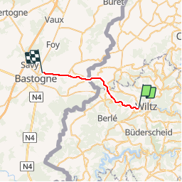

Length
16.3 km

Max alt
496 m

Uphill gradient
369 m
Km-Effort
21 km

Min alt
317 m

Downhill gradient
194 m
Boucle
No
Creation date :
2018-07-11 17:42:05.227
Updated on :
2018-07-11 17:46:06.64

FREE GPS app for hiking
 SityTrail
IGN / Geographical institutes
SityTrail Plus
The world is yours!
About
Trail of 16.3 km to be discovered at Unknown, Canton Wiltz, Wiltz. This trail is proposed by Moss.
Positioning
Country:
Luxembourg
Region :
Unknown
Department/Province :
Canton Wiltz
Municipality :
Wiltz
Location:
Unknown
Start:(Dec)
Start:(UTM)
709172 ; 5538821 (31U) N.
Comments