


20180717 Boucle Ry par Vascoeuil

Childebert
User
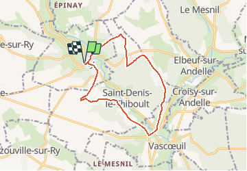

Length
12.4 km

Max alt
166 m

Uphill gradient
218 m
Km-Effort
15.3 km

Min alt
56 m

Downhill gradient
218 m
Boucle
Yes
Creation date :
2018-07-13 07:56:26.866
Updated on :
2018-07-13 08:14:39.039
3h18
Difficulty : Medium

FREE GPS app for hiking
 SityTrail
IGN / Geographical institutes
SityTrail Plus
The world is yours!
About
Trail Walking of 12.4 km to be discovered at Normandy, Seine-Maritime, Ry. This trail is proposed by Childebert.
Positioning
Country:
France
Region :
Normandy
Department/Province :
Seine-Maritime
Municipality :
Ry
Location:
Unknown
Start:(Dec)
Start:(UTM)
379812 ; 5481153 (31U) N.
Comments