


38 dizimieu

trietsch
User
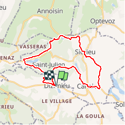

Length
15.7 km

Max alt
410 m

Uphill gradient
378 m
Km-Effort
21 km

Min alt
279 m

Downhill gradient
373 m
Boucle
Yes
Creation date :
2016-03-09 00:00:00.0
Updated on :
2020-01-04 20:30:43.156
4h23
Difficulty : Easy

FREE GPS app for hiking
 SityTrail
IGN / Geographical institutes
SityTrail Plus
The world is yours!
About
Trail Walking of 15.7 km to be discovered at Auvergne-Rhône-Alpes, Isère, Dizimieu. This trail is proposed by trietsch.
Positioning
Country:
France
Region :
Auvergne-Rhône-Alpes
Department/Province :
Isère
Municipality :
Dizimieu
Location:
Unknown
Start:(Dec)
Start:(UTM)
678726 ; 5065362 (31T) N.
Comments