


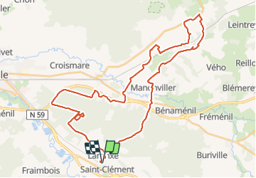
sortie vtt du 14/07/2018 Embermenil

fabwin
User GUIDE

Length
45 km

Max alt
307 m

Uphill gradient
416 m
Km-Effort
50 km

Min alt
229 m

Downhill gradient
415 m
Boucle
Yes
Creation date :
2018-07-14 15:00:08.015
Updated on :
2018-07-15 07:23:17.568
2h45
Difficulty : Easy

FREE GPS app for hiking
 SityTrail
IGN / Geographical institutes
SityTrail Plus
The world is yours!
About
Trail Mountain bike of 45 km to be discovered at Grand Est, Meurthe-et-Moselle, Saint-Clément. This trail is proposed by fabwin.
Description
Sortie solo sous le soleil
Test et réglages ok!!
Emberménil
Photos


Positioning
Country:
France
Region :
Grand Est
Department/Province :
Meurthe-et-Moselle
Municipality :
Saint-Clément
Location:
Unknown
Start:(Dec)
Start:(UTM)
323012 ; 5378520 (32U) N.
Comments