Trail Walking Autoire - Autoire - Loubressac - Photo

Autoire - Loubressac

 neitag61
neitag61

User

© OpenStreetMap contributors
Length
Length
10.4 km
Max alt
Max alt
386 m
Uphill gradient
Uphill gradient
349 m
Km-Effort
Km-Effort  
15.1 km
Min alt
Min alt
167 m
Downhill gradient
Downhill gradient
351 m
Boucle
Boucle
Yes
Creation date :
2018-07-15 14:51:50.831
Updated on :
2018-07-15 15:16:01.512

(0 Reviews)

Walking
Walking
3h09
Difficulty : Medium

Scan this QR Code to open this trail in the SityTrail application

FREE GPS app for hiking

Logo SityTrail SityTrail

IGN / Geographical institutes

Download SityTrail from the App Store Download SityTrail from Google Play

Logo SityTrail SityTrail World

The world is yours!

Download SityTrail from the App Store Download SityTrail from Google Play Download SityTrail on Huawei AppGallery

About

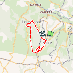
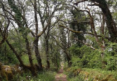
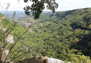
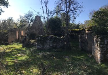
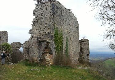
Trail Walking of 10.4 km to be discovered at Occitania, Lot, Autoire. This trail is proposed by neitag61.

Description

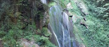
2 plus beaux villages de France en passant par la cascade d'Autoire.

quelques passages délicat pour des personnes sensibles aux vertiges.

à faire de préférence dans le sens horaire.

Elevation profile

Photos

Points of interest

Point of interest Loubressac - Dolmen - Photo
neitag61
LOUBRESSAC 
Point of interest Loubressac - Fontaine - Photo
neitag61
LOUBRESSAC 
Point of interest Autoire - Cascade - Photo
neitag61
AUTOIRE 

Positioning

Country:
France
Region :
Occitania
Department/Province :
Lot
Municipality :
Autoire
Location:
Unknown
Start:(UTM)
406926 ; 4967622 (31T) N.

Trails nearby

Trail Walking Loubressac - Nos plus beaux villages - Photo
Walking
alain2306

Walking

Difficult
(1)
Loubressac, Occitania, Lot, France
9.9 km | 14.2 km-effort
3h 0min
Yes
Trail Walking Prudhomat - autour de castelnau - Photo
Walking
lefrancm

Walking

Very easy
(1)
Prudhomat, Occitania, Lot, France
3.5 km | 4.8 km-effort
1h 48min
No
Trail Walking Loubressac - Loubressac-Château des Anglais - Photo
Walking
werth

Walking

Easy
Loubressac, Occitania, Lot, France
8.6 km | 12.1 km-effort
2h 21min
Yes
Trail On foot Saint-Jean-Lespinasse - St Jean Lespinasse - La Césarine - Photo
On foot
PRO

On foot

Easy
Saint-Jean-Lespinasse, Occitania, Lot, France
3.8 km | 5.9 km-effort
1h 20min
Yes
Trail Walking Loubressac - autoire cascade siran - Photo
Walking
Forsans

Walking

Medium
Loubressac, Occitania, Lot, France
5.5 km | 8.4 km-effort
1h 55min
No
Trail Walking Loubressac - Laguizayrie - Photo
Walking
Gaillard Isabelle

Walking

Easy
Loubressac, Occitania, Lot, France
15.9 km | 20 km-effort
3h 59min
Yes
Trail Walking Saint-Jean-Lespinasse - La Causse de Lauriol - Photo
Walking
richardsimopons

Walking

Saint-Jean-Lespinasse, Occitania, Lot, France
10.6 km | 14.2 km-effort
3h 6min
Yes
Trail Walking Autoire - segonzac autoire - Photo
Walking
bellouelo46

Walking

Easy
Autoire, Occitania, Lot, France
11.9 km | 15.9 km-effort
3h 0min
Yes
Trail Walking Saint-Céré - De Saint Céré à Gintrac - Photo
Walking
sdroneau

Walking

Medium
Saint-Céré, Occitania, Lot, France
25 km | 34 km-effort
6h 0min
No


Close
My subscriptions