


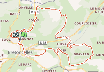
8895616-Bretoncelles 13.67

togolo28
User

Length
14 km

Max alt
233 m

Uphill gradient
248 m
Km-Effort
17.3 km

Min alt
132 m

Downhill gradient
248 m
Boucle
Yes
Creation date :
2018-07-16 17:08:57.127
Updated on :
2019-12-19 15:16:03.14
3h39
Difficulty : Easy

FREE GPS app for hiking
 SityTrail
IGN / Geographical institutes
SityTrail Plus
The world is yours!
About
Trail Walking of 14 km to be discovered at Normandy, Orne, Bretoncelles. This trail is proposed by togolo28.
Positioning
Country:
France
Region :
Normandy
Department/Province :
Orne
Municipality :
Bretoncelles
Location:
Unknown
Start:(Dec)
Start:(UTM)
343662 ; 5366885 (31U) N.
Comments