


2018-07-15 Marche Dreistein Mt Ste Odile Birkenfels Kagengels

holtzv
User GUIDE
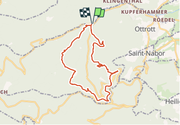

Length
16 km

Max alt
771 m

Uphill gradient
601 m
Km-Effort
24 km

Min alt
343 m

Downhill gradient
601 m
Boucle
Yes
Creation date :
2018-07-15 06:50:31.209
Updated on :
2018-07-16 20:10:50.12
5h49
Difficulty : Very easy

FREE GPS app for hiking
 SityTrail
IGN / Geographical institutes
SityTrail Plus
The world is yours!
About
Trail Walking of 16 km to be discovered at Grand Est, Bas-Rhin, Ottrott. This trail is proposed by holtzv.
Description
Avec Guillaume Vonbank
Positioning
Country:
France
Region :
Grand Est
Department/Province :
Bas-Rhin
Municipality :
Ottrott
Location:
Unknown
Start:(Dec)
Start:(UTM)
380770 ; 5368601 (32U) N.
Comments