


sortie vtt du 27072018 nocturne

fabwin
User GUIDE
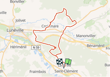

Length
46 km

Max alt
285 m

Uphill gradient
292 m
Km-Effort
50 km

Min alt
224 m

Downhill gradient
293 m
Boucle
Yes
Creation date :
2018-07-27 17:43:05.466
Updated on :
2018-07-28 10:38:43.31
1h52
Difficulty : Medium

FREE GPS app for hiking
 SityTrail
IGN / Geographical institutes
SityTrail Plus
The world is yours!
About
Trail Mountain bike of 46 km to be discovered at Grand Est, Meurthe-et-Moselle, Saint-Clément. This trail is proposed by fabwin.
Photos


Positioning
Country:
France
Region :
Grand Est
Department/Province :
Meurthe-et-Moselle
Municipality :
Saint-Clément
Location:
Unknown
Start:(Dec)
Start:(UTM)
323007 ; 5378512 (32U) N.
Comments