


GR34 2018091

drarep
User
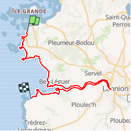

Length
31 km

Max alt
67 m

Uphill gradient
654 m
Km-Effort
40 km

Min alt
-1 m

Downhill gradient
650 m
Boucle
No
Creation date :
2018-07-30 17:45:06.069
Updated on :
2018-09-07 11:57:10.559
8h37
Difficulty : Medium

FREE GPS app for hiking
 SityTrail
IGN / Geographical institutes
SityTrail Plus
The world is yours!
About
Trail Walking of 31 km to be discovered at Brittany, Côtes-d'Armor, Trébeurden. This trail is proposed by drarep.
Positioning
Country:
France
Region :
Brittany
Department/Province :
Côtes-d'Armor
Municipality :
Trébeurden
Location:
Unknown
Start:(Dec)
Start:(UTM)
457554 ; 5403432 (30U) N.
Comments