Trail Cycle Midway - Chilliwack-Hope Alternate Cycling route Connector - Photo

Chilliwack-Hope Alternate Cycling route Connector

 xenkod
xenkod

User

© OpenStreetMap contributors
Length
Length
490 km
Max alt
Max alt
1325 m
Uphill gradient
Uphill gradient
8271 m
Km-Effort
Km-Effort  
602 km
Min alt
Min alt
178 m
Downhill gradient
Downhill gradient
8555 m
Boucle
Boucle
No
Creation date :
2018-08-01 08:15:03.067
Updated on :
2018-08-01 08:50:23.262

(0 Reviews)

Cycle
Cycle
--
Difficulty : Very easy

Scan this QR Code to open this trail in the SityTrail application

FREE GPS app for hiking

Logo SityTrail SityTrail

IGN / Geographical institutes

Download SityTrail from the App Store Download SityTrail from Google Play

Logo SityTrail SityTrail World

The world is yours!

Download SityTrail from the App Store Download SityTrail from Google Play Download SityTrail on Huawei AppGallery

About

Trail Cycle of 490 km to be discovered at British Columbia, Regional District of Kootenay Boundary, Midway. This trail is proposed by xenkod.

Elevation profile

Positioning

Country:
Canada
Region :
British Columbia
Department/Province :
Regional District of Kootenay Boundary
Municipality :
Midway
Location:
Unknown
Start:(UTM)
369416 ; 5430299 (11U) N.

Trails nearby

Trail Cycle Midway - Chilliwack-Hope Alternate Cycling route Connector - Photo
Cycle
xenkod

Cycle

Very easy
Midway, British Columbia, Regional District of Kootenay Boundary, Canada
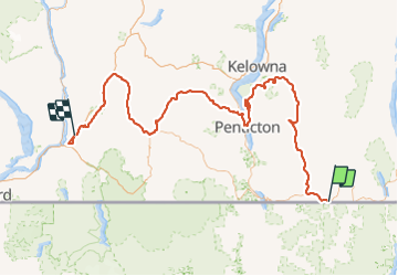
490 km | 602 km-effort
Unknown
No


Close
My subscriptions