


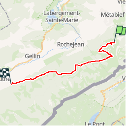
Mouthe Mt d'Or retour

drarep
User

Length
17.8 km

Max alt
1386 m

Uphill gradient
386 m
Km-Effort
24 km

Min alt
939 m

Downhill gradient
756 m
Boucle
No
Creation date :
2018-08-03 18:14:30.026
Updated on :
2018-09-07 12:43:02.516
4h55
Difficulty : Medium

FREE GPS app for hiking
 SityTrail
IGN / Geographical institutes
SityTrail Plus
The world is yours!
About
Trail Walking of 17.8 km to be discovered at Bourgogne-Franche-Comté, Doubs, Longevilles-Mont-d'Or. This trail is proposed by drarep.
Positioning
Country:
France
Region :
Bourgogne-Franche-Comté
Department/Province :
Doubs
Municipality :
Longevilles-Mont-d'Or
Location:
Unknown
Start:(Dec)
Start:(UTM)
297770 ; 5180497 (32T) N.
Comments