


circuit des arcs

fitz2014
User

Length
6.2 km

Max alt
95 m

Uphill gradient
50 m
Km-Effort
6.8 km

Min alt
58 m

Downhill gradient
50 m
Boucle
Yes
Creation date :
2018-08-05 17:38:51.455
Updated on :
2018-08-05 19:06:34.333
1h27
Difficulty : Very easy

FREE GPS app for hiking
 SityTrail
IGN / Geographical institutes
SityTrail Plus
The world is yours!
About
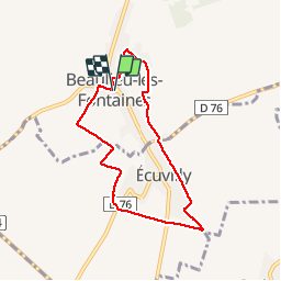
Trail Walking of 6.2 km to be discovered at Hauts-de-France, Oise, Beaulieu-les-Fontaines. This trail is proposed by fitz2014.
Positioning
Country:
France
Region :
Hauts-de-France
Department/Province :
Oise
Municipality :
Beaulieu-les-Fontaines
Location:
Unknown
Start:(Dec)
Start:(UTM)
493734 ; 5500670 (31U) N.
Comments