Trail Walking Saint-Apollinaire - Aiguilles Chabrieres 08/08/18 - Photo
 R@ph
R@ph

User GUIDE

© OpenStreetMap contributors
Length
Length
11 km
Max alt
Max alt
2353 m
Uphill gradient
Uphill gradient
978 m
Km-Effort
Km-Effort  
24 km
Min alt
Min alt
1456 m
Downhill gradient
Downhill gradient
977 m
Boucle
Boucle
Yes
Creation date :
2018-08-09 08:37:41.357
Updated on :
2018-08-09 09:03:03.053

(0 Reviews)

Walking
Walking
4h42
Difficulty : Medium
Climbing
Climbing
15m
Difficulty : Easy

Scan this QR Code to open this trail in the SityTrail application

FREE GPS app for hiking

Logo SityTrail SityTrail

IGN / Geographical institutes

Download SityTrail from the App Store Download SityTrail from Google Play

Logo SityTrail SityTrail World

The world is yours!

Download SityTrail from the App Store Download SityTrail from Google Play Download SityTrail on Huawei AppGallery

About

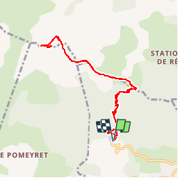
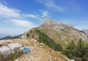
Trail Walking of 11 km to be discovered at Provence-Alpes-Côte d'Azur, Hautes-Alpes, Saint-Apollinaire. This trail is proposed by R@ph.

Description

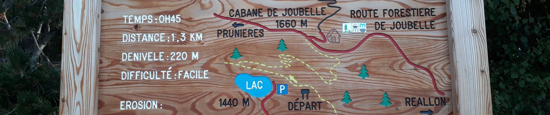
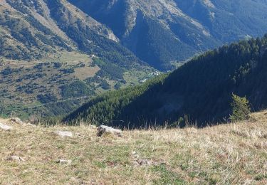
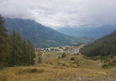
Départ du lac de St Appolinaire avec un passage par la cabane de Joubelle et sa source rafraichissante. On rejoint le Serre du mouton avant de prendre la crête jusqu'au sommet de la station de Reallon. Ce passage offre un superbe point de vue sur le lac de Serre Ponçon et les sommets voisins. On franchi ensuite la casse de Chabrières puis une montée dans la brèche jusqu'au Oucanes.
Pour le sommet des aiguilles on contourne celles-ci par le nord puis une montée à vue. Attention de ne pas rater le passage par la cheminée et ensuite un passage aérien avant le sommet.  

Elevation profile

Photos

Positioning

Country:
France
Region :
Provence-Alpes-Côte d'Azur
Department/Province :
Hautes-Alpes
Municipality :
Saint-Apollinaire
Location:
Unknown
Start:(UTM)
289272 ; 4937760 (32T) N.

Trails nearby

Trail Walking Réallon - AIguilles de Chabrieres au départ de la Station de ski Reallon - Photo
Walking
Maca8284

Walking

Very difficult
(1)
Réallon, Provence-Alpes-Côte d'Azur, Hautes-Alpes, France
14 km | 25 km-effort
6h 0min
Yes
Trail Walking Réallon - Aiguilles de Chabrière - Photo
Walking
GUIDE
David25400

Walking

Easy
(1)
Réallon, Provence-Alpes-Côte d'Azur, Hautes-Alpes, France
12.2 km | 23 km-effort
5h 35min
Yes
Trail Walking Réallon - le fort de Réallon - Photo
Walking
gildascb

Walking

Very easy
(1)
Réallon, Provence-Alpes-Côte d'Azur, Hautes-Alpes, France
8 km | 11.8 km-effort
2h 11min
Yes
Trail Walking Réallon - SityTrail - 2556786 - aiguilles-de-chabriere - Photo
Walking
GUIDE
amiral13

Walking

Difficult
Réallon, Provence-Alpes-Côte d'Azur, Hautes-Alpes, France
11.8 km | 23 km-effort
6h 0min
Yes
Trail Snowshoes Réallon - Raquettes Réallon  - Photo
Snowshoes
GUIDE
David25400

Snowshoes

Easy
Réallon, Provence-Alpes-Côte d'Azur, Hautes-Alpes, France
6.5 km | 14.3 km-effort
3h 27min
Yes
Trail Walking Réallon - Reallon-Serre du Mouton 7km - Photo
Walking
GUIDE
thonyc

Walking

Easy
Réallon, Provence-Alpes-Côte d'Azur, Hautes-Alpes, France
7.3 km | 13 km-effort
2h 53min
Yes
Trail Mountain bike Savines-le-Lac - circuit de serre verger N°25 - Photo
Mountain bike
guariso

Mountain bike

Medium
(1)
Savines-le-Lac, Provence-Alpes-Côte d'Azur, Hautes-Alpes, France
9.8 km | 15.8 km-effort
1h 30min
No
Trail Walking Saint-Apollinaire - Aiguilles de Chabrières - Photo
Walking
DaumasChris

Walking

Medium
(1)
Saint-Apollinaire, Provence-Alpes-Côte d'Azur, Hautes-Alpes, France
13.1 km | 26 km-effort
4h 47min
Yes
Trail Snowshoes Réallon - les chalets du Vaucluse - Photo
Snowshoes
Maca8284

Snowshoes

Very easy
Réallon, Provence-Alpes-Côte d'Azur, Hautes-Alpes, France
7.1 km | 9.8 km-effort
2h 54min
Yes


Close
My subscriptions