


Vtt cendron 2018

D4Y.be
User
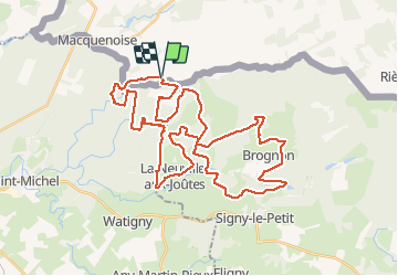

Length
43 km

Max alt
322 m

Uphill gradient
638 m
Km-Effort
52 km

Min alt
236 m

Downhill gradient
642 m
Boucle
Yes
Creation date :
2018-08-15 06:47:15.938
Updated on :
2018-08-20 16:04:56.159
2h31
Difficulty : Easy

FREE GPS app for hiking
 SityTrail
IGN / Geographical institutes
SityTrail Plus
The world is yours!
About
Trail Mountain bike of 43 km to be discovered at Wallonia, Hainaut, Momignies. This trail is proposed by D4Y.be.
Photos

Positioning
Country:
Belgium
Region :
Wallonia
Department/Province :
Hainaut
Municipality :
Momignies
Location:
Macquenoise
Start:(Dec)
Start:(UTM)
587531 ; 5534881 (31U) N.
Comments