


footing cers

rmc59
User
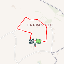

Length
1.5 km
Boucle
Yes
Creation date :
2018-08-17 14:30:26.363
Updated on :
2018-08-17 14:34:17.107
20m
Difficulty : Very easy

FREE GPS app for hiking
 SityTrail
IGN / Geographical institutes
SityTrail Plus
The world is yours!
About
Trail Running of 1.5 km to be discovered at Occitania, Hérault, Cers. This trail is proposed by rmc59.
Positioning
Country:
France
Region :
Occitania
Department/Province :
Hérault
Municipality :
Cers
Location:
Unknown
Start:(Dec)
Start:(UTM)
526849 ; 4798086 (31T) N.
Comments