


Pommiers

fitz2014
User
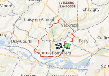

Length
11.6 km

Max alt
136 m

Uphill gradient
150 m
Km-Effort
13.6 km

Min alt
37 m

Downhill gradient
154 m
Boucle
Yes
Creation date :
2018-08-18 12:18:48.832
Updated on :
2021-08-01 10:34:58.867
3h01
Difficulty : Difficult

FREE GPS app for hiking
 SityTrail
IGN / Geographical institutes
SityTrail Plus
The world is yours!
About
Trail Walking of 11.6 km to be discovered at Hauts-de-France, Aisne, Pommiers. This trail is proposed by fitz2014.
Positioning
Country:
France
Region :
Hauts-de-France
Department/Province :
Aisne
Municipality :
Pommiers
Location:
Unknown
Start:(Dec)
Start:(UTM)
519867 ; 5471283 (31U) N.
Comments